Know what climate change means for this address — before it costs you.
Climate Remit turns flood maps, bushfire ratings, wind zoning and sea-level projections into one engineering-grade report for a single property, built around its design, construction and location.
The financial cost of a changing climate
Extreme weather is no longer a once-a-decade event. For property owners, that shift shows up as repair bills, insurance premiums and, eventually, resale value — often years before a hazard map catches up.
Costly repairs
Damage from flood, fire, wind and shifting soils is expected to increase steadily over the working life of a mortgage, well beyond what routine maintenance budgets assume.
Rising premiums
A growing share of properties in exposed locations are approaching the point where insurance becomes difficult to obtain at an affordable rate.
Market devaluation
As buyers, lenders and insurers price in climate exposure, high-risk properties are starting to sell for less than comparable properties on safer ground.
Two ways to put climate risk data to work
Individual households
For homeowners, homebuyers, sellers and renters who want to understand the climate risk attached to one specific address before they buy, sell, insure or renovate.
Property service providers
For real estate professionals, valuers, lenders, insurers and developers who need dependable, quantitative risk data to support transaction and reporting decisions across many properties.
Quantifying a property's climate risk
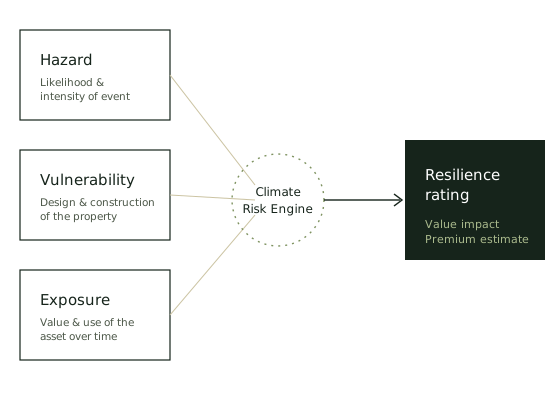
Every Climate Remit report is generated by a Climate Risk Engine that combines the physical hazard at a location with the specific design and construction of the property, then projects both forward against IPCC AR6 climate pathways to 2050 and 2100.
The result is a resilience rating, a technical insurance premium estimate and a climate-adjusted value — not a generic postcode-level score.
Read about our methodologyHazards we assess
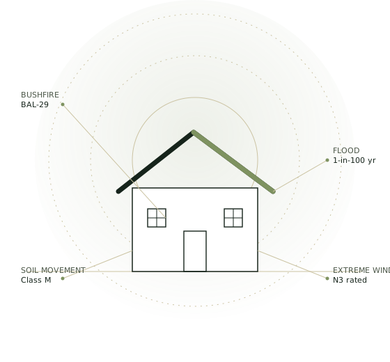
Our analysis covers the physical hazards most likely to affect a property's safety, insurability and long-term value.
Riverine & flash flooding
Catchment precipitation that exceeds river or drainage capacity and inundates nearby land.
Coastal inundation & sea-level rise
High sea-level events and long-term sea-level rise affecting low-lying coastal land.
Bushfire
Fire spread through vegetation, assessed using construction-relevant attack level ratings.
Soil movement
Reactive soils that expand and contract, shifting foundations over time.
Extreme wind
Wind loads at or beyond a building's design specification, outside cyclonic events.
Trusted by homeowners and property professionals
“The report was clear and easy to follow. It flagged flood exposure on a property we were about to make an offer on — information we would not otherwise have had.”
Priya M. — First home buyer“We use Climate Remit reports as part of our standard due diligence now. The hazard-by-hazard breakdown is far more useful than a single risk score.”
Daniel R. — Buyer's agent“Understanding the bushfire attack level before we renovated changed our materials list and, honestly, our insurance quote too.”
Sarah K. — HomeownerFind out the climate risk to your property
Enter an address and get an engineering-grade report covering flood, fire, wind, soil movement and sea-level risk — delivered to your inbox.